Signature One
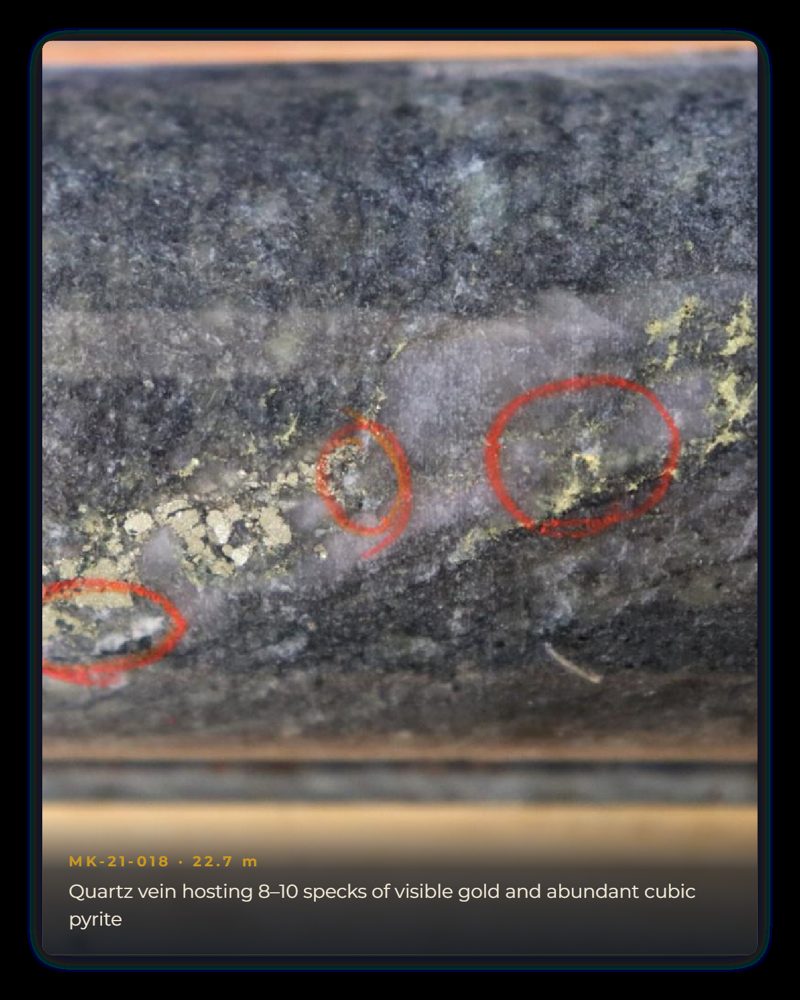
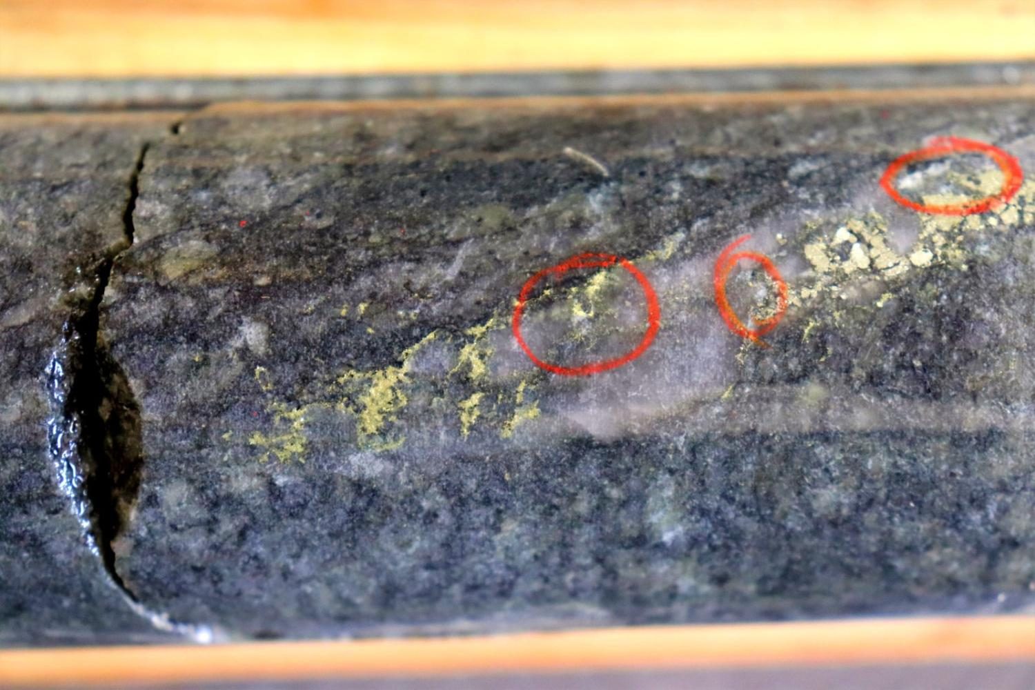
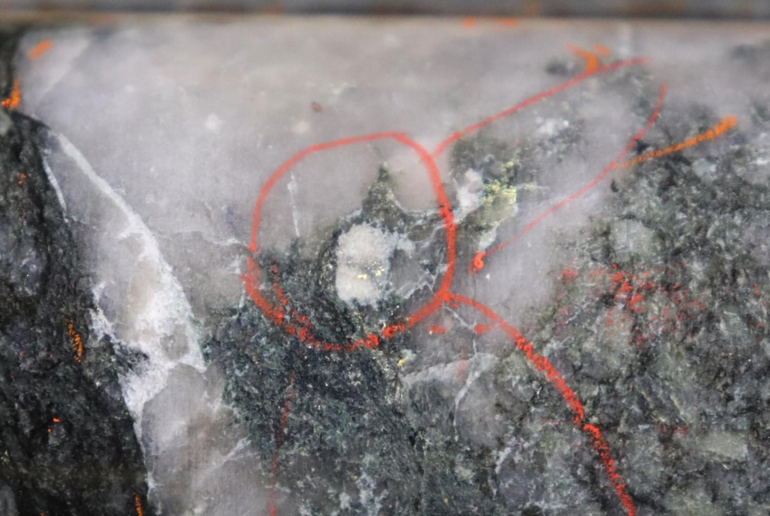
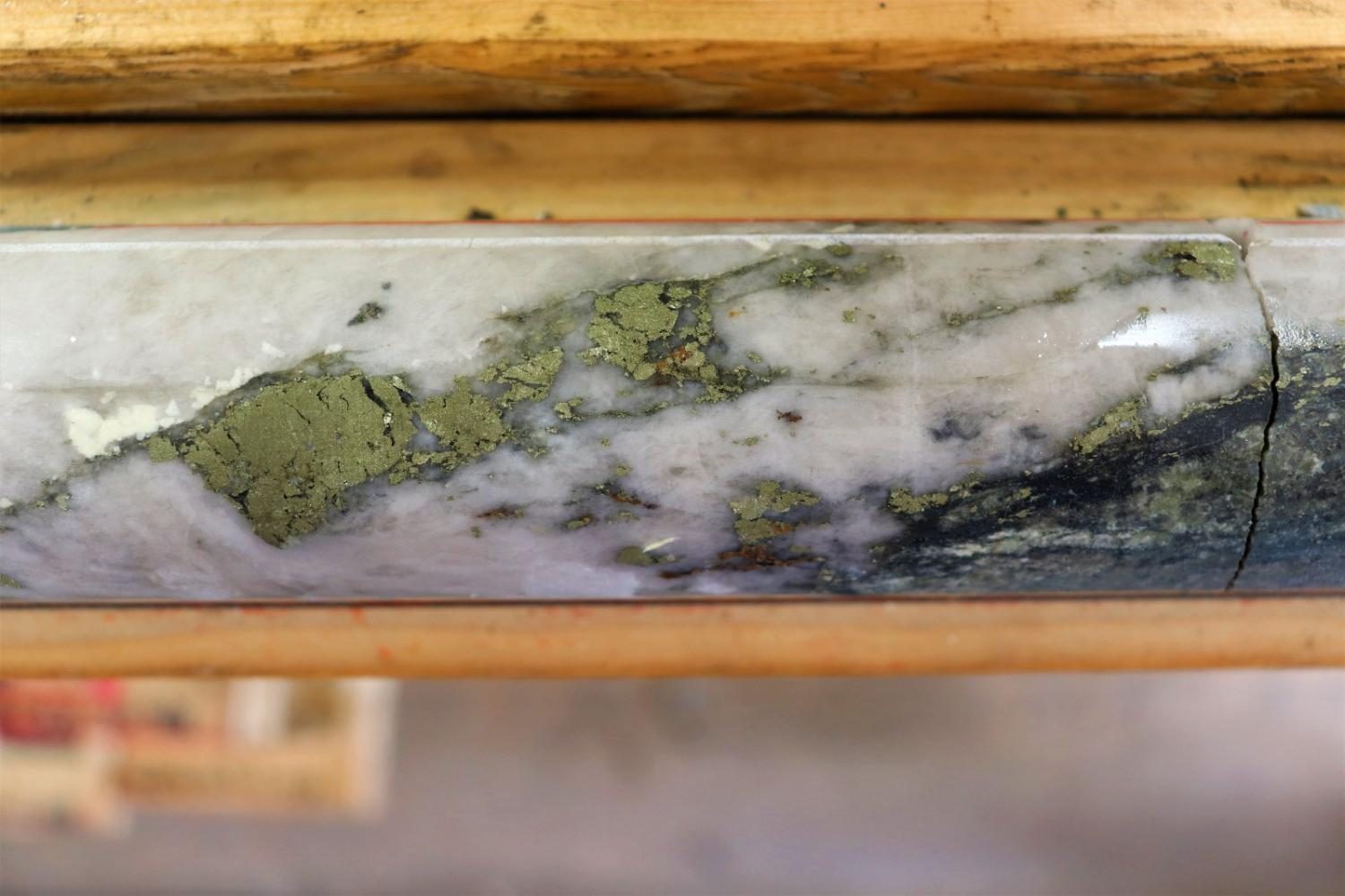
High-Grade Quartz Veins
Narrow, visible-gold-bearing veins with abundant coarse pyrite, replicating the historic drill results on the property. Individual metres have assayed 23.10, 26.70, 59.80 and 94.20 g/t Au.

The Property
1,398 hectares straddling the St. Paul's Bay area and Perch Lake. Two drill campaigns have outlined a mineralized system that appears to continue along strike.
1,398 ha
A single land package in the Red Lake camp, proximal to deposits and historic production.
Road access
Easy access on paved roads, with an existing power line crossing the district.
2 campaigns
Drilling completed in 2020 and 2021, with core logged and cut at a secure facility in Red Lake.
~500 m
Strike length established to date; the zone appears to continue northeast across and north of Perch Lake.
The Gold System
Drilling at McKenzie has outlined a well-mineralized gold system that combines higher-grade gold in quartz veins with lengthy near-one-gram intercepts permeating out into the intrusives.
Signature One
Narrow, visible-gold-bearing veins with abundant coarse pyrite, replicating the historic drill results on the property. Individual metres have assayed 23.10, 26.70, 59.80 and 94.20 g/t Au.
Signature Two
50 m to 300 m intervals of disseminated, near-one-gram gold through the host intrusives — the disseminated style that historically defined the wider Hasaga system.
17 of 19 of the first holes drilled at McKenzie returned gold intercepts of at least 1 g/t Au.
2020–2021 Drilling
MK-21-019 ended in mineralization, averaging 0.74 g/t Au over its entire 283.4 m length.
MK-21-018
2.78 g/t over 37.6 m
including 24.7 m @ 4.05 g/t, 8 m @ 12.14 g/t and 1 m @ 94.20 g/t Au
MK-21-019
1.25 g/t over 136.5 m
including 44.9 m @ 3.00 g/t, 15.5 m @ 5.25 g/t and 1 m @ 59.80 g/t Au
MK-21-018 · Upper Zone
1.01 g/t over 56 m
including 21.5 m @ 1.84 g/t, 10 m @ 3.30 g/t and 1 m @ 23.10 g/t Au
MK-20-006 · High Grade
13.25 g/t over 2.75 m
including 36.2 g/t Au over 1 m
Reported lengths are downhole intercepts and are not true widths. Grades are uncapped.
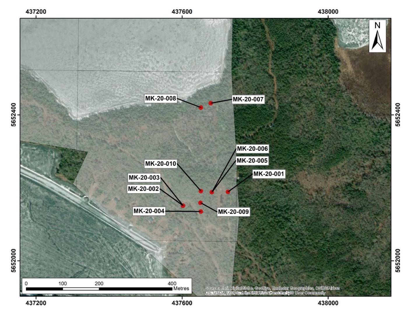
First Campaign · August 2020
Ten holes tested the project area from surface, returning both narrow high-grade veins and the first long, lower-grade envelopes.
| Hole ID | Significant intercept |
|---|---|
| MK-20-006 | 13.25 g/t Au over 2.75 m — incl. 36.2 g/t over 1 m |
| MK-20-008 | 0.62 g/t Au over 117.5 m — incl. 55 m @ 1.00, 16 m @ 1.42 |
| MK-20-007 | 0.33 g/t Au over 117.4 m — incl. 9.4 m @ 1.26, 1.5 m @ 4.64 |
| MK-20-004 | 7.43 g/t Au over 1 m |
| MK-20-001 | 1.41 g/t Au over 4 m — incl. 4.3 g/t over 1 m; 5.75 g/t over 0.5 m |
| MK-20-005 | 3.42 g/t over 1 m; 5.27 g/t over 0.5 m; 1.61 g/t over 1 m |
| MK-20-010 | 2.94 g/t Au over 2 m; 4.05 g/t over 1 m |
| MK-20-002 | 5.21 g/t Au over 0.5 m |
Second Campaign · 2021
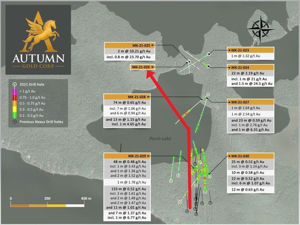
Step-out drilling established nearly 500 m of strike length that appears to continue northeast, across and north of Perch Lake.
| Hole ID | Significant intercept |
|---|---|
| MK-21-025 | 10.21 g/t Au over 2 m — incl. 23.70 g/t over 0.8 m |
| MK-21-024 | 2.19 g/t Au over 22 m — incl. 21 g/t over 1 m, 24.5 g/t over 1.5 m |
| MK-21-028 | 0.65 g/t Au over 74 m; 1.15 g/t over 13 m incl. 4.65 g/t over 1 m |
| MK-21-029 | 0.52 g/t Au over 133 m; 1.37 g/t over 7 m incl. 6.77 g/t over 1 m |
| MK-21-030 | 0.52 g/t Au over 25 m; 0.52 g/t over 22 m incl. 1.07 g/t over 6 m |
| MK-21-027 | 0.59 g/t Au over 23 m — incl. 6.31 g/t over 1 m, 2.76 g/t over 1 m |
2021 Drill Program
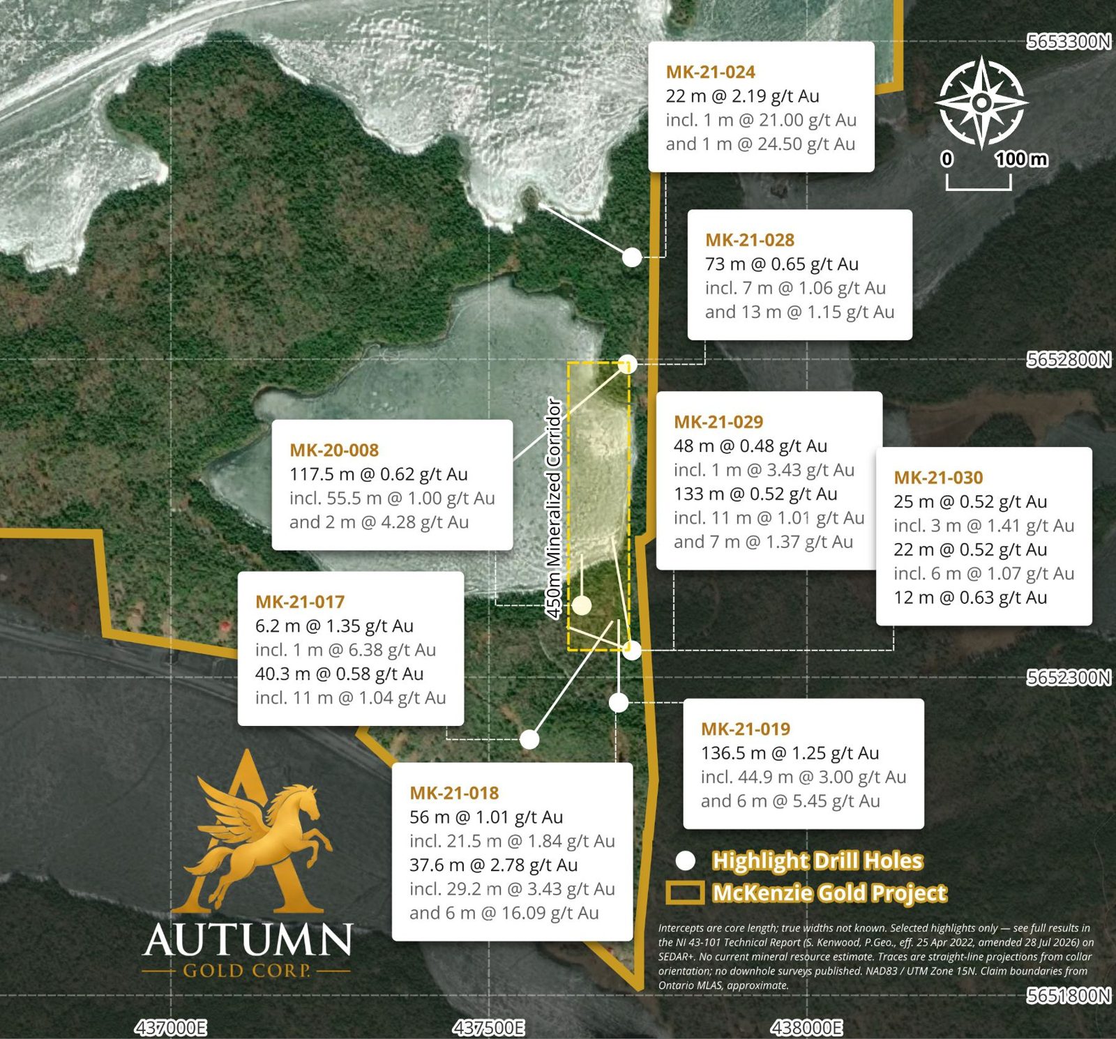
Eight holes drilled across the 100%-owned claim block, with a 450 m mineralized corridor identified at its centre.
| Hole ID | Length (m) | Au (g/t) | Includes |
|---|---|---|---|
| MK-20-008 | 117.5 | 0.62 | 55.5 m @ 1.00 · 2 m @ 4.28 |
| MK-21-017 | 6.2 | 1.35 | 1 m @ 6.38 |
| MK-21-017 | 40.3 | 0.58 | 11 m @ 1.04 |
| MK-21-018 | 56.0 | 1.01 | 21.5 m @ 1.84 |
| MK-21-018 | 37.6 | 2.78 | 29.2 m @ 3.43 · 6 m @ 16.09 |
| MK-21-019 | 136.5 | 1.25 | 44.9 m @ 3.00 · 6 m @ 5.45 |
| MK-21-024 | 22.0 | 2.19 | 1 m @ 21.00 · 1 m @ 24.50 |
| MK-21-028 | 73.0 | 0.65 | 7 m @ 1.06 · 13 m @ 1.15 |
| MK-21-029 | 48.0 | 0.48 | 1 m @ 3.43 |
| MK-21-029 | 133.0 | 0.52 | 11 m @ 1.01 · 7 m @ 1.37 |
| MK-21-030 | 25.0 | 0.52 | 3 m @ 1.41 |
| MK-21-030 | 22.0 | 0.52 | 6 m @ 1.07 |
| MK-21-030 | 12.0 | 0.63 | — |
MK-21-018 — 37.6 m @ 2.78 g/t Au, including 29.2 m @ 3.43 g/t and 6 m @ 16.09 g/t Au. The corridor remains open along strike and at depth.
Selected highlights only. Intercepts are core length; true widths are not known. See the NI 43-101 Technical Report (S. Kenwood, P.Geo., eff. 25 Apr 2022, amended 28 Jul 2026) on SEDAR+ for full results. No current mineral resource estimate. Collars NAD83 UTM Zone 15N.
Drill Core
Free gold and coarse pyrite logged through the 2021 program — the same veins that returned single metres of 23.10, 59.80 and 94.20 g/t Au.
What Comes Next
A three-step programme aimed at building the data set for a preliminary resource estimate.
Infill and extend the nearly 500 m of established strike, including below MK-21-019, where the hole was terminated while still in gold mineralization.
Define the known system
Explore and identify new zones across and beyond Perch Lake, along the trend interpreted from the 2021 drilling, where the system is untested.
Grow the footprint
Compile drilling, assay and structural data to support a preliminary resource estimate on the St. Paul's Bay area. Two campaigns of assay and collar data are already in hand.
Toward a maiden estimate
A well-mineralized system, in a producing camp, on road access — and still untested along strike and below the deepest holes.
Untested
Along strike
Untested
At depth